Lanzarote Volcano Tour: The Complete Guide to the Island's Volcanic Landscapes
The coach pulls into the Timanfaya car park at 11:15am. Forty-five passengers file out, follow the path to the restaurant, watch a chicken being lowered into a geothermal vent, take a photo, get back on the coach. Thirty minutes later they're gone. They've "done" the volcanoes.
Meanwhile, three kilometres away, a trail runs along the edge of a collapsed lava tube where the ground is still warm underfoot. The silence is total. The landscape looks like something from a different planet. There is no one else here. There is no coach, no restaurant, no queue. Just 300 years of solidified lava stretching to the Atlantic in every direction.
This guide covers both versions of a lanzarote volcano tour. The well-known sites that deserve your time (and the ones that don't deserve as much as they get), and the volcanic landscapes that most visitors never reach because no one told them they existed.
Understanding Lanzarote's Volcanic History
You can't appreciate what you're looking at without knowing what happened here. And what happened here is one of the most destructive volcanic events in recorded European history.
The Eruptions of 1730 to 1736
On the 1st of September, 1730, the earth opened near the village of Timanfaya. What followed was not a single eruption but a continuous volcanic event lasting six years. Over 100 volcanic vents opened in sequence, burying a quarter of the island under lava and ash. Eleven villages were destroyed completely. The most fertile agricultural land on Lanzarote vanished under metres of basalt.
The parish priest of Yaiza, Padre Lorenzo Curbelo, kept a diary of the eruptions. His account is one of the most remarkable primary documents in volcanological history. He described rivers of lava reaching the sea and boiling the water for miles, new mountains appearing overnight, and an atmosphere so thick with ash and sulphur that the remaining population considered abandoning the island entirely.
They didn't abandon it. They adapted. The volcanic destruction that should have ended human habitation on Lanzarote instead produced the landscape, the agriculture, and the culture that define the island today. The wine region of La Geria, the salt pans of Janubio, the architecture of every village rebuilt from volcanic stone: all of it grew directly from catastrophe.
The 1824 Eruption and the Volcanic Present
A shorter eruption in 1824 created three additional volcanic cones near Timanfaya. This was the last eruptive event on Lanzarote, but the island is far from geologically dormant. Temperatures at shallow depth beneath Timanfaya still reach 400 to 600 degrees Celsius. The geothermal demonstrations at the national park restaurant, where water poured into a pipe returns as a steam geyser within seconds, are not theatre. They're a direct reminder that the volcanic system below the surface remains active.
Lanzarote sits on the same tectonic hotspot that feeds the volcanic systems of Fuerteventura, Tenerife, and La Palma (which erupted as recently as 2021). The island's volcanoes are not extinct. They are sleeping.
Timanfaya National Park: What to Expect and How to Do It Right
Timanfaya is the centrepiece of any lanzarote volcano tour, and for good reason. It's a genuine national park protecting one of the most spectacular volcanic landscapes in Europe. But the standard visitor experience barely scratches what's here.
The Coach Route Through the Fire Mountains
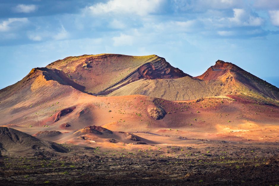
The Ruta de los Volcanes is a 14-kilometre coach route through the heart of the lava fields. You cannot drive it yourself. Visitors board coaches at the Islote de Hilario (the central visitor area) and are driven through the landscape while a recorded narration plays. The route passes through landscapes of extraordinary colour and form: lava rivers frozen mid-flow, volcanic cones in shades of red, black, and ochre, craters where you can see the layered geology of each eruption.
It is, by any measure, impressive. The problem is the format. You're on a coach, behind glass, for approximately 25 minutes. You cannot stop. You cannot get out. You cannot walk up to the formations that catch your eye. It's a scenic drive through one of the most geologically significant sites in the Atlantic, experienced at the pace and perspective of a bus tour.
Practical tips for Timanfaya:
Arrive early or late. The car park fills by 11am in peak season. Before 10am or after 3pm, the queues are manageable and the light on the lava fields is dramatically better for photography.
The geothermal demonstrations are worth seeing. The geyser, the brushwood that ignites from ground heat alone, the chicken cooked over a volcanic vent: they're not gimmicks. They illustrate the reality of what's still happening beneath your feet.
The restaurant is better than you'd expect. Designed by César Manrique (as is much of what's worth seeing on the island), El Diablo restaurant sits on the volcanic summit with panoramic views. The food is grilled over geothermal heat from the volcano itself. Not a marketing trick: the grill sits above a natural volcanic vent.
Budget 90 minutes total. That's enough for the coach route, the demonstrations, and a meal or coffee at the restaurant without feeling rushed.
What the Standard Timanfaya Visit Misses
The coach route covers a fraction of the national park. Timanfaya encompasses 51 square kilometres of protected volcanic terrain, and the vast majority of it is inaccessible to the general public. No walking trails, no viewpoints, no access roads. This is deliberate: the lava fields are ecologically fragile, and the national park authority restricts access to preserve them.
But there are ways in. Guided hikes within Timanfaya are available through the national park service, led by official guides along designated routes. These walks take you into the lava fields on foot, at ground level, where you can see the textures, colours, and geological detail that the coach window turns into a blur. Tremesana and the Litoral Route are the two main guided options. They must be booked in advance, they're free, and they fill up quickly. Reserve your spot as soon as your travel dates are confirmed.
Insider tip: The Litoral Route along the coast, where the lava fields meet the Atlantic, is the more visually dramatic of the two. The contrast between molten black rock and turquoise water, with the volcanic cones rising behind, is one of the most striking landscapes in the Canary Islands.
Beyond Timanfaya: The Volcanic Landscapes Most Visitors Miss
Here's what most lanzarote excursions don't tell you: the volcanic landscape doesn't stop at the national park boundary. Timanfaya protects the core eruption zone, but the lava fields, volcanic cones, and geological formations extend across the entire southern and central part of the island. Much of the most accessible and rewarding volcanic scenery on Lanzarote lies outside the national park, in areas you can explore freely and on foot.
Los Volcanes Natural Park
Immediately surrounding Timanfaya, the Parque Natural de Los Volcanes covers a much larger area of volcanic terrain that is open to hikers. This is where the island reveals itself to anyone willing to leave the car. Trails wind through lava fields, past volcanic cones you can climb, across terrain that shifts from jagged aa lava to smooth, ropy pahoehoe flows within a few hundred metres.
The Caldera Blanca hike is the standout. A moderate trail (roughly 9km round trip) leads to the rim of a massive volcanic crater, one of the largest on the island. The final section follows the crater rim with views across the entire lava field, the Timanfaya cones, and the Atlantic. On a clear day, which is most days on Lanzarote, the view stretches to Fuerteventura.
Practical tip: Start the Caldera Blanca hike early, before 9am in summer. There is zero shade on the route, the volcanic rock absorbs and radiates heat, and the temperature on an exposed lava trail in July can be fifteen degrees higher than what the weather app shows for Arrecife.
Montaña Roja and the Southern Cones
The volcanic cones around Playa Blanca in the south of the island are some of the most photogenic on Lanzarote and among the easiest to reach. Montaña Roja, a vivid red-and-orange cone at the tip of the island, offers a short, steep climb (about 30 minutes) to a summit with views across to Fuerteventura, the Papagayo beaches, and the Rubicón plain.
The colour of Montaña Roja is not the typical grey-black of the Timanfaya lava fields. The iron-rich minerals in its rock have oxidised over millennia, producing the deep reds and burnt oranges that give the mountain its name. At sunset, the colours intensify to the point of appearing artificial. They're not.
La Corona and the Northern Volcanic Landscape
The northern end of the island has its own volcanic story, older and different in character from the Timanfaya eruptions. Monte Corona, a large volcanic cone near Haría, erupted roughly 21,000 years ago and produced one of the most remarkable geological features on Lanzarote: a lava tube stretching over six kilometres from the cone to the coast, where it continues underwater.
Two sections of this tube are open to the public and both rank among the most impressive things to do in Lanzarote.
Cueva de los Verdes
A one-kilometre section of the Corona lava tube, dramatically lit and guided. The scale of the tube is startling. Passages reach 15 metres in height, with multiple levels formed as successive lava flows carved new channels through the solidified rock of earlier flows. The guided tour takes about 50 minutes and includes a genuinely unexpected visual surprise at the end that has been delighting visitors for decades. We won't spoil it.
Cueva de los Verdes also hosts occasional concerts inside the lava tube. The acoustics in the main cavern, shaped by thousands of years of geological formation, are extraordinary. If a concert coincides with your visit, prioritise it.
Jameos del Agua

The other accessible section of the Corona lava tube, transformed by César Manrique into one of his most celebrated interventions. Where Cueva de los Verdes is pure geology, Jameos del Agua is geology combined with architecture, art, and landscape design. Manrique built a restaurant, a concert hall, and a swimming pool inside and around the natural cave formations, creating a space where volcanic rock, tropical plants, and water coexist.
The underground lake at the base of the jameo (collapsed section of the tube) is home to a species of blind albino crab (Munidopsis polymorpha) found nowhere else on earth. These tiny white crabs have become an unofficial symbol of the site and of Lanzarote's unique ecology.
Insider tip: Visit Jameos del Agua in the late afternoon when the tour groups have left and the light drops into the open jameo from above, illuminating the cave pool and turning the water an impossible shade of turquoise. This is the version of the site that Manrique designed for, not the midday version with 200 people on the terrace.
Volcanic Hiking: The Routes Worth Your Time
Lanzarote is not typically thought of as a hiking destination, which is precisely why it's such a good one. The trails are uncrowded, the volcanic terrain provides constant visual interest, and the Atlantic light gives the landscape a clarity that makes every viewpoint feel cinematic.
Caldera Blanca (Top Pick)
Already mentioned above, but worth emphasising. This is the single best volcanic hike on the island. The approach across the lava field, the ascent to the crater rim, and the panoramic view from the top combine into something that rivals any day hike in the Canaries. Difficulty is moderate: no scrambling, no exposure, but the distance and the heat require reasonable fitness and proper preparation.
Montaña de Guardilama
A lesser-known cone rising above the La Geria wine valley. The hike to the summit (about 45 minutes from the base) rewards with a view that ties the island's volcanic and viticultural stories together: the lava fields of Timanfaya to the west, the zocos of La Geria spreading below, and the sea in every other direction. If you're combining a lanzarote volcano tour with a visit to the wine region, Guardilama is the physical link between the two.
The Tremesana Route (Timanfaya Guided Walk)
The national park guided hike through terrain that's otherwise off-limits. Approximately 3km, led by a park guide who explains the geology, the ecology, and the ongoing volcanic processes beneath the surface. Free but must be reserved in advance through the park office. This is the closest you'll get to the core eruption zone on foot.
The Coastal Lava Trails: El Golfo to Los Hervideros
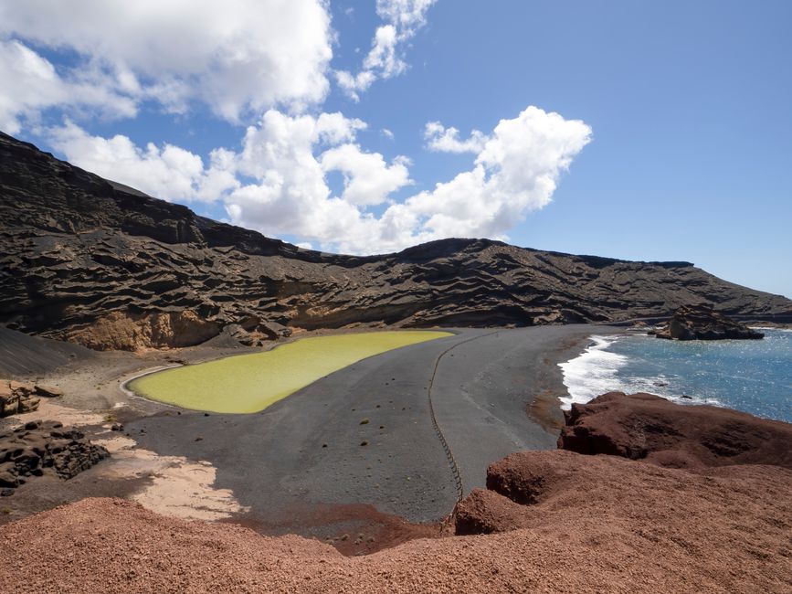
The stretch of coastline between El Golfo and Los Hervideros, along the western edge of the lava fields, is where the volcanic landscape meets the Atlantic in the most dramatic fashion. Lava flows reach the sea in frozen cascades of black rock. At Los Hervideros, the ocean has carved caves and arches into the lava cliffs, and the waves compress into the cavities with a force that makes the rock vibrate. On a day with Atlantic swell, the spray from Los Hervideros can reach twenty metres.
The green lagoon at El Golfo, a half-crater open to the sea, contains a lake coloured vivid green by the algae Ruppia maritima. Against the black and red of the surrounding volcanic rock, the effect is startling. It's one of the most photographed sites on Lanzarote, and one of the few that looks even more striking in person than in photographs.
Planning Your Lanzarote Volcano Tour
Here's how to structure your time depending on how deep you want to go.
The Half-Day Essentials
If you have half a day, focus on Timanfaya National Park and the western coastline. Drive to Timanfaya early, do the coach route and geothermal demonstrations, then continue south along the coast to El Golfo (green lagoon) and Los Hervideros (sea caves). Stop at the Janubio salt pans on the way back. This covers the core volcanic highlights and can be done comfortably in four to five hours.
The Full-Day Deep Dive
Start with the Caldera Blanca hike early in the morning. After the hike, drive to Timanfaya for the coach route (the queue will have thinned by early afternoon). Continue to El Golfo and Los Hervideros for the coastal volcanic formations. End the day in the La Geria wine valley for a tasting at one of the bodegas, because drinking Malvasía grown in volcanic soil after a day spent walking across that same volcanic landscape is one of the best lanzarote activities you can put together. A long day, but one that covers the full volcanic story from eruption to agriculture.
The Multi-Day Volcanic Experience
If your interest runs deeper, Lanzarote rewards it. Add the northern volcanic sites (Cueva de los Verdes, Jameos del Agua, Monte Corona) on a separate day. Book the Tremesana or Litoral guided walk inside Timanfaya. Explore the less-visited cones around Tinajo and Tao, where the 1730 eruption trail began. Walk the Malpaís de la Corona, the ancient lava field in the north that's home to the hidden gems of the island's geological past.
Three days of dedicated volcanic exploration still won't exhaust what's here. Lanzarote is a small island built on an enormous geological story.
What to Wear and Bring
Essential gear for volcanic hiking:
Sturdy footwear. Volcanic rock is sharp and abrasive. Trail shoes minimum, hiking boots preferred. Flip-flops on lava are a recipe for injury.
Sun protection. There is no shade on volcanic terrain. Hat, high-SPF sunscreen, and sunglasses are not optional.
Water. More than you think you need. There are no water sources on volcanic trails, and the heat reflected from black lava dehydrates faster than you expect.
Layers. Lanzarote's trade winds can make exposed ridgelines and crater rims surprisingly cold, even when the valley below is warm. A lightweight windbreaker fits in any bag.
Camera. The volcanic landscapes are extraordinarily photogenic, especially in early morning and late afternoon light when the textures of the lava fields are most defined.
César Manrique and the Volcanic Aesthetic
You cannot talk about Lanzarote's volcanic landscape without talking about César Manrique. The artist, architect, and environmentalist born in Arrecife in 1919 did more than any other individual to shape how the island relates to its volcanic geology.
Manrique saw the lava fields not as wasteland but as art. His life's work was integrating human space with volcanic landscape: homes built into lava bubbles, restaurants inside volcanic caves, gardens carved from lava flows. His own home, now the Fundación César Manrique, was built inside five volcanic bubbles connected by tunnels, with the natural rock formations becoming walls, ceilings, and design features.
His influence extends beyond the sites that bear his name. Manrique campaigned successfully to ban high-rise buildings and roadside billboards across the island. The reason Lanzarote looks different from the overdeveloped coastlines of mainland Spain and many other Canary Islands is largely because of Manrique's insistence that the volcanic landscape itself was the island's greatest asset, and that architecture should serve it rather than compete with it.
Visiting the Manrique sites, Jameos del Agua, Mirador del Río, the Cactus Garden, the Fundación, is as much a part of a lanzarote volcano tour as visiting the volcanoes themselves. They show what happens when someone truly understands a volcanic landscape and builds with it rather than on top of it.
Frequently Asked Questions
Are the volcanoes in Lanzarote still active?
Lanzarote's volcanoes are classified as dormant, not extinct. The last eruption was in 1824, and geothermal measurements at Timanfaya show temperatures of 400 to 600 degrees Celsius at shallow depths. The volcanic system beneath the island remains active, which is why Timanfaya's geothermal demonstrations work: the heat is real and ongoing. Lanzarote sits on the same volcanic hotspot as La Palma, which erupted in 2021.
How long do you need for a Lanzarote volcano tour?
A half-day covers the essentials: Timanfaya National Park coach route, geothermal demonstrations, and the El Golfo/Los Hervideros coastline. A full day allows you to add the Caldera Blanca hike and a wine tasting in La Geria. For a thorough exploration including the northern lava tubes (Cueva de los Verdes, Jameos del Agua), the guided Timanfaya walks, and lesser-known volcanic sites, plan two to three days spread across your trip.
Can you walk inside Timanfaya National Park?
General access within Timanfaya is restricted to the coach route and the Islote de Hilario visitor area. However, the national park offers free guided walks (Tremesana Route and Litoral Route) that take small groups into the lava fields on foot. These must be booked in advance through the park's visitor centre and fill up quickly, especially in peak season. Outside the national park boundary, the surrounding Los Volcanes Natural Park has open hiking trails including the popular Caldera Blanca route.
What is the best time of year for a Lanzarote volcano tour?
Lanzarote's mild climate makes volcanic exploration possible year-round, but conditions vary. October to April offers cooler temperatures ideal for hiking (15 to 22 degrees Celsius) with fewer tourists. Summer (June to August) is hotter, which makes long hikes demanding, but the extended daylight hours give more flexibility. The clearest skies tend to be in late spring and autumn. Avoid hiking in the midday heat during summer: start at dawn and the volcanic landscapes reward you with the best light and the fewest people.
Is a Lanzarote volcano tour suitable for families?
Timanfaya's coach route and geothermal demonstrations are suitable for all ages and genuinely fascinating for children. The Manrique sites (Jameos del Agua, Cueva de los Verdes) are family-friendly, and the blind albino crabs at Jameos del Agua are a guaranteed hit with young visitors. For hiking, Montaña Roja near Playa Blanca is a manageable climb for older children, and the coastal formations at Los Hervideros are impressive from the roadside viewpoints without requiring any walking. Caldera Blanca is better suited to teenagers and adults due to the distance and heat exposure.
Do I need a guide for a Lanzarote volcano tour?
For Timanfaya National Park, the coach route is the only way to see the interior. The guided walks within the park require an official park guide. For the rest of the island's volcanic sites, you can explore independently with a rental car and a good map. That said, having a knowledgeable guide transforms a volcanic landscape from "impressive scenery" into a comprehensible geological story. The difference between looking at a lava field and understanding what you're looking at, which eruption formed it, why the rock changes colour, what's happening underground, is the difference between seeing Lanzarote and understanding it.
Want a lanzarote volcano tour that goes beyond the standard coach ride? We design private volcanic experiences that combine the major sites with the hidden trails, the geological stories, and the landscapes that most visitors never reach. Get in touch with our team to build your itinerary. Or explore our Volcano and Nature experiences to see what's possible.


